
Whidbey Island Critters
Re: Whidbey Island Critters
Happy Holidays to all, everywhere ... ")
http://JanKocian.smugmug.com
I take photos because I like it, not because I'm good at it. by Unknown
I take photos because I like it, not because I'm good at it.
Re: Whidbey Island Critters
Last dive before I departed Whidbey , just before the storm hit in full force the next day. Holmes Harbor in Freeland providing sheltered waters from the strong southerly winds.


http://JanKocian.smugmug.com
I take photos because I like it, not because I'm good at it. by Unknown
I take photos because I like it, not because I'm good at it.
Re: Whidbey Island Critters
Jan: I have never dived Holmes Harbor, but I have some pleasant memories of evenings at anchor there. I seem to remember that you found some sand dollars there once. Am I right? And Merry Christmas to you as well.
-Curt
-Curt
Happy to be alive.
Re: Whidbey Island Critters
Curt, there are Sand dollars here, but did not see them on this dive.
Lion's mane jellyfish encounter, Holmes Harbor.


Lion's mane jellyfish encounter, Holmes Harbor.
http://JanKocian.smugmug.com
I take photos because I like it, not because I'm good at it. by Unknown
I take photos because I like it, not because I'm good at it.
Re: Whidbey Island Critters
Langley Harbor. Critters and little bit of history about the tire reef which made this locality a dive destination in the past, before the expansion of the harbor closed it for diving. There is now noticeable decline in variety and numbers of marine life comparing to the "good old days". And I am not even talking about the sea star population crash. There are hundreds of baby stars now present, but if it will return to "normal" is uncertain. The Sunflower stars are missing in the picture. But when the winter winds batter the coastline of Whidbey, Langley usually provides save haven for a survey dive.


http://JanKocian.smugmug.com
I take photos because I like it, not because I'm good at it. by Unknown
I take photos because I like it, not because I'm good at it.
Re: Whidbey Island Critters
Happy New Year.
"Beauty is everywhere - you only have to look to see it." (Bob Ross).
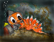
Even in the mouth of the Painted sea anemone...


"Beauty is everywhere - you only have to look to see it." (Bob Ross).
Even in the mouth of the Painted sea anemone...
http://JanKocian.smugmug.com
I take photos because I like it, not because I'm good at it. by Unknown
I take photos because I like it, not because I'm good at it.
Re: Whidbey Island Critters
Last dive of 2018 - Skyline.


http://JanKocian.smugmug.com
I take photos because I like it, not because I'm good at it. by Unknown
I take photos because I like it, not because I'm good at it.
Re: Whidbey Island Critters
January 1. First dive of 2019 - Possession Point Fingers...


http://JanKocian.smugmug.com
I take photos because I like it, not because I'm good at it. by Unknown
I take photos because I like it, not because I'm good at it.
Re: Whidbey Island Critters
Possession Point Fingers. Red Irish Lords guarding eggs and Northern Kelp Crabs congregate ...


http://JanKocian.smugmug.com
I take photos because I like it, not because I'm good at it. by Unknown
I take photos because I like it, not because I'm good at it.
Re: Whidbey Island Critters
Thank you Jan for this amazing thread ... I enjoy every post
NWDC Rule #2 Pictures Or it didn't Happen
Re: Whidbey Island Critters
Thanks Chris, the enjoyment is mutual, I like your work too...
Skyline, Fidalgo Island. Black sea cucumbers spawning. As they do every December ...


Skyline, Fidalgo Island. Black sea cucumbers spawning. As they do every December ...
http://JanKocian.smugmug.com
I take photos because I like it, not because I'm good at it. by Unknown
I take photos because I like it, not because I'm good at it.
Re: Whidbey Island Critters
This winter seems to punch our region hard. The storm of December 20 completely changed the Keystone Jetty landscape above the water. My first dive there since that storm, this time on glassy calm day, provided some new features underwater as well. The Keystone Harbor Entrance Light 2 did not survive the fury of the seas and now provides home to Northern Kelp Crabs


http://JanKocian.smugmug.com
I take photos because I like it, not because I'm good at it. by Unknown
I take photos because I like it, not because I'm good at it.
Re: Whidbey Island Critters
The wall built to protect the Keystone boat launch area was not a match for the destructive power of the storm.

http://JanKocian.smugmug.com
I take photos because I like it, not because I'm good at it. by Unknown
I take photos because I like it, not because I'm good at it.
Re: Whidbey Island Critters
Keystone Jetty Saturday dive, more views from underwater, post storm scenery. Chunk of concrete bearing the Geo marker ended up underwater, many feet away from its original position. The Wrinkled dogwinkle snails are gathering for their annual mating/ egg laying, covering many of the jetty rocks. As do Leafy hornmouths. Who named these snails ?


http://JanKocian.smugmug.com
I take photos because I like it, not because I'm good at it. by Unknown
I take photos because I like it, not because I'm good at it.
Re: Whidbey Island Critters
Another place which was hit hard by the December wind storm, not far from Keystone, is the appropriately named Driftwood Park. Lot of the driftwood which gave the beach its name ended up in the two shallow ponds created during road construction. Some of the wood even covered the main highway and was later moved to the roadside where it now competes with the beach as Driftwood Park attraction. And some of it floats on top of the ponds, so it was only natural for me to done my dive gear and go in to see, what it looks like under the surface. The visibility was of course lousy, the fish eye lens makes it look better than it is. I was looking for critters which could possibly enter the pond along with the flotsam ocean waves brought in across the breach. But I found only Moon jellies, which were there before the calamity. The bottom is muck and chunks of what used to be grass covered shore now rest under the surface. My drysuit leaked, so getting soaked during my excursion added to the feeling of desolation of the place. :(


http://JanKocian.smugmug.com
I take photos because I like it, not because I'm good at it. by Unknown
I take photos because I like it, not because I'm good at it.
Re: Whidbey Island Critters
Two more critters from Skyline dive...


http://JanKocian.smugmug.com
I take photos because I like it, not because I'm good at it. by Unknown
I take photos because I like it, not because I'm good at it.
Re: Whidbey Island Critters
It has been a while since I visited Keystone's old wharf, better known as The Pilings. It used to be a home to clouds of fish, many octopus and juvenile Wolf eels and Plumose and Painted anemones were presented in much more numbers. But as the time passes, there is less and less of variety, so I now visit the cathedral of pilings only occasionally. I could see right away that lot of the decking is gone, victim to the December 20, 2018 storm, ropes now hang between some of the pilings, remnants of lost crab traps, and the only fish in any numbers were the Tubesnout.
Young Cabezon was the only "prize"...


Young Cabezon was the only "prize"...
http://JanKocian.smugmug.com
I take photos because I like it, not because I'm good at it. by Unknown
I take photos because I like it, not because I'm good at it.
Re: Whidbey Island Critters
Keystone is hosting gathering of Wrinkled dogwinkle snails as it does every winter. This year it seems that there are attending the reproductive convention in larger numbers than year ago.
Is this happening in such numbers elsewhere in Puget Sound also ?


Is this happening in such numbers elsewhere in Puget Sound also ?
http://JanKocian.smugmug.com
I take photos because I like it, not because I'm good at it. by Unknown
I take photos because I like it, not because I'm good at it.
Re: Whidbey Island Critters
Keystone Jetty mix. Some above and some under. If the beach erosion continues, we will be soon parking on the highway :(
Although the scene above looks bleak, there is still color to be found underwater.


Although the scene above looks bleak, there is still color to be found underwater.
http://JanKocian.smugmug.com
I take photos because I like it, not because I'm good at it. by Unknown
I take photos because I like it, not because I'm good at it.
Re: Whidbey Island Critters
A common cycle for beaches consists of erosion of during winter storms followed by deposition from river sediments during spring runoffs. Whidbey Island suffers from having no rivers to recharge the sediment, so you have only half of the cycle. Some of your beaches are sustained from erosion of adjacent bluffs.
-Curt
-Curt
Happy to be alive.
Re: Whidbey Island Critters
Is the parking area at Keystone man made? As we all know, mother nature usually doesn't take much pity on things that aren't supposed to be there! As long as the water keeps following the erosion back towards the road and they relocate the bathroom, I'm ok with it! More of the jetty underwater would be an ok tradeoff for less parking.
Party underwater
Re: Whidbey Island Critters
I don't know the history, I think the parking area is fine, but the tailings from dredging were just deposited there and as I recall not much of compacting went into the effort. I am not engineer, but remember Pete shoveling access path on the new deposited rim, it was very loose, so I am not surprised that every really high tide took some of the material back to sea. Visibility since that dredging never returned to the good old days before dredging. Even Lingcod were covered with silt.
http://JanKocian.smugmug.com
I take photos because I like it, not because I'm good at it. by Unknown
I take photos because I like it, not because I'm good at it.
Re: Whidbey Island Critters
The season of Lingcod guarding egg masses is upon us.
Be prepared for encounters with some bad tempered individuals


Be prepared for encounters with some bad tempered individuals
http://JanKocian.smugmug.com
I take photos because I like it, not because I'm good at it. by Unknown
I take photos because I like it, not because I'm good at it.
Re: Whidbey Island Critters
Langley Harbor survey. Only one wasted sea star, which is a good news.
What I found interesting was the large gathering on Noble dorids.


What I found interesting was the large gathering on Noble dorids.
http://JanKocian.smugmug.com
I take photos because I like it, not because I'm good at it. by Unknown
I take photos because I like it, not because I'm good at it.
Re: Whidbey Island Critters
The currents were not the friendliest, visibility only about 12 silty feet, but Deception Pass is always a treat. Frost on the ground and only visitors on the beach were two seagulls looking for a handout. No wasting observed in any of the sea stars, so another survey with welcome results.


http://JanKocian.smugmug.com
I take photos because I like it, not because I'm good at it. by Unknown
I take photos because I like it, not because I'm good at it.