Hello all,
I have another question, it's about dive site mapping. First I was wondering if people could post the maps they have made so everyone can see. Also I was wondering the best method for creating your own dive site maps. I have found three ways:
1. Dive a bunch of times and hand sketch it out. (cheapest)
2. Get a handheld gps and tow it on the surface and take pictures along your dive with a camera displaying times, so you can later check the gps and note where you were at what depths. (Cheaper)
3. Buy a Hummingbird fish finder or a side scan sonar and drive over each site with a boat and transfer the information into a mapping program (very very exspensive)
Also does anyone have any tips on a good landscape software to draw up the maps, like autocad map 3d, or bryce5.
Thanks
Sheahan
Underwater Mapping

I think that most shops tend to keep the dive site maps that their DM candidates make. Not sure why, but, that has been my experience.
Some will release their maps for others to enjoy.
In the meantime, Janna's site has a bunch of pretty good maps linked there.
Some will release their maps for others to enjoy.
In the meantime, Janna's site has a bunch of pretty good maps linked there.
Tim
SSI Dive Control Specialist Instructor
REEF PNW AAT Level 5 Surveyor
REEF Hawaii Level 3 Surveyor
REEF Instructor - PNW Fish, PNW Advanced Fish, PNW Inverts, TWA, HAW, TEP, Cal Inverts and Algae
TimRenz.com creating comfortable, confident, and enthusiastic divers.
SSI Dive Control Specialist Instructor
REEF PNW AAT Level 5 Surveyor
REEF Hawaii Level 3 Surveyor
REEF Instructor - PNW Fish, PNW Advanced Fish, PNW Inverts, TWA, HAW, TEP, Cal Inverts and Algae
TimRenz.com creating comfortable, confident, and enthusiastic divers.

I only have stick maps that were shared with me for caves. Most were drawn by my sources from memory and then transcribed by me into my wetnotes for use on the dives.
When folks ask me for beta on local dive sites there's Janna's list of sites. Otherwise I just draw it out on paper without a scale.
I guess the tools you need and/or choose depend on the end user and purpose of the map. Maybe you could elaborate on that?
When folks ask me for beta on local dive sites there's Janna's list of sites. Otherwise I just draw it out on paper without a scale.
I guess the tools you need and/or choose depend on the end user and purpose of the map. Maybe you could elaborate on that?
-
sheahanmcculla
- I've Got Gills
- Posts: 1387
- Joined: Wed Jun 13, 2007 11:54 am
I am not sure about what I wanted for the end result I first was looking for a way to make a really nice site map for my Dive Master but then it turned into something more. I like this idea: http://arttomedia.hdtshop.com/site/Home.aspx
Hmmm there alot of graphics on those. Do you have suitable software like photoshop? How about the time? They are nice but I can see the full color wow factor is mostly useful to generate sales not because its required or even helpful UW.
Here's an example of a cave map from my wetnotes
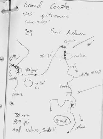
So I guess I'd try to ID what you want to do with them. E.g. a full color glossy map to hang on a wall as decoration need not be true to scale. So rather than spend time and energy measuring to the foot, just spend your time drawing. Vs. a map like the EUP map which is navigational tool and would just fade if it were full color, but being close to true on scale is helpful.
Here's an example of a cave map from my wetnotes
So I guess I'd try to ID what you want to do with them. E.g. a full color glossy map to hang on a wall as decoration need not be true to scale. So rather than spend time and energy measuring to the foot, just spend your time drawing. Vs. a map like the EUP map which is navigational tool and would just fade if it were full color, but being close to true on scale is helpful.
If I were you, I would approach each method from the surface, trying each method in a park or something. For instance, the GPS method to me is difficult even on the surface - for 2 reasons - at the scales you are likely interested in, GPS is not accurate enough, and, unless the GPS you are using exports a plot, you will have a hard time relating the GPS coordinates to your map.
If you map out a park on the surface(using any method), and then have someone else check it, you can see how accurate you can be there. If it is accurate there, then you can take what you learned under water. One thing that is better underwater than in the park is that you have a quite accurate depth. So you can take depth readings at various landmarks (watermarks?), and you can take compass readings to other visible items from there.
There are all kinds of possibilities once you have your map information though. For instance, you can use Google sketchup to make a 3d- map and then import that into Google Earth, and then your map can be incorporated into a real representation of the area, and can be viewed from different angles and so forth.
I am very interested in surveying, and would like to know about what you accomplish. I will likely explore things in this direction myself.
S'Mike
Behold, the King reigns! You are his publicity agents. Therefore advertise, advertise, advertise, the King and his kingdom.
-
sheahanmcculla
- I've Got Gills
- Posts: 1387
- Joined: Wed Jun 13, 2007 11:54 am
-
sheahanmcculla
- I've Got Gills
- Posts: 1387
- Joined: Wed Jun 13, 2007 11:54 am
Thanks for the idea, I was thinking of a rope type measuring tape, but I thought it was a dumb idea. I like your idea. Here is a sketch i drew up in autocad for an example of what i want to do i know it's missing things, i'll ad them later.
- Attachments
-
Last edited by sheahanmcculla on Thu Apr 07, 2011 11:41 am, edited 1 time in total.
-
sheahanmcculla
- I've Got Gills
- Posts: 1387
- Joined: Wed Jun 13, 2007 11:54 am
Yeah I doubt you can twist a photo. But the rendering should be nice. And Autocad will allow you to do gobs of distance-bearing + z axis points easily. Just keep plugging them in.
You will probably want to sketch in the "between point" data. E.g. record the ends of a log + depth. Then sketch in the actual log. Or record the bow and stern of a boat. Measure the width seperately. Then sketch the boat in positon/orientation. You can make up teh flare of the bow better than you could measure it.
2 or 3 measurements of each feature in your wetnotes or on a big slate should be adequate.
If you get into a position where stuff isn't "fitting" Autocad does have a survey module that can compute nearest neighbor positions and "fix" slight deviations. Hope it doesn't come to that.

Sounds time consuming, but very logical!CaptnJack wrote:Get yourself a reel and mark the line with a knot every 10ft. Start from a known location and go to the structure you are trying to reference. Take a magnetic bearing and count knots for distance.
Distance and bearing + depth
Distance and bearing + depth
repeat over and over
Kind of like the K.I.S.S. method huh?
Hi, my name is Keith, and I'm a Dive Addict! 
I didn't look at your autocad drawing very closely until today, and I realized that you are mapping Mukilteo, like I am too I'm not sure how to share a file, I have a start of a google sketchup map of Mukilteo. I have not located the string and the log that you have, but they look right from my visits to them.
I started with profile maps I found from USGS, and overlaid them into sketchup, redrew the profile lines, used a tool to create a profile, then added the docks using the google earth imported into sketchup to get the dimensions to the docks. I then sighted the red bouy for the geodome with a compass, and located it on my map. I also the bottom of it was about 65'.
Would you share what you know about relative locations?
S'mike
Behold, the King reigns! You are his publicity agents. Therefore advertise, advertise, advertise, the King and his kingdom.
-
sheahanmcculla
- I've Got Gills
- Posts: 1387
- Joined: Wed Jun 13, 2007 11:54 am
S’mike, I am glad to see someone else is interested in taking the time to create more detailed maps of some popular dive sites. Are you working on your Dive master? I looked into sketchup at one time but it looks hard to use. I was not aware you could overlay the usgs topo maps in sketchup. That’s pretty cool. You can also overlay them in 2 other programs “Bryce5” and “3DEM” Both are free and have better rendering capabilities. Could you post or email me what you have? A screen shot would work if you can’t figure out how to send it. I would love to see it. Here is what I know about Mukilteo:
The line you saw is about 50 yards straight out from the stairs. It runs Parallel to the beach and is for students to do their skills. There is a street sign on the north end, and a concrete slab on the south.
If you head down slope from the concrete slab you will find the log going from west to east. There is a commercial crab pot also if you go down straight out from the log (60-70 fsw)
There is a horse north east of the geodome (never been there) in about 70-80fsw.
There is a pvc/metal creation if you go northeast from the end of the T-dock in about 60-65 fsw
Some old 55-gallon drums and a corvette fender is to the left of the T-dock about ¾ of the way to the end.
There is a boat at 130fsw past the geo dome (I have not been there but have been told there is always a gpo underneath)
That's all I know for now. I dive there a lot since it’s close. I’m sure there is more, but I just need to explore. Or bring some stuff down with me.
Sheahan
This is cool.
If either of you would like a buddy for some of your mapping dives let me know, I dive down there about once a week, be glad to help out.
There is also a log north of the T-dock at about 105. Slightly upslope (100-95fsw) there are 3 old crab pots and a few tires that usually have some life on them. A line runs from there down to the boat.
Don't forget the kitchen sink between the log and the geodome too.
Jake
I just did dive #10 (extreme noob) - but very interested in mapping.
How long is the rope? I have gone the length of it and am guessing 100'.
I got the spacing of the dock pilings from the google map satellite images (but have not added them to my model yet). Took a copy of the sat image out to the beach and sighted the geodome bouy with dive compass, and the end of T-dock and the other dock. Sighted the geodome bouy from the other dock too, and placed it using the sightings.
Did you know that the bottom is 900' down straight out there? Off the clay walls by the park, it goes to over 1200'. When you place that in your model the recreational depth area that we dive in looks so small.
Admittedly, the contours I have are very rough, and I can only place a couple of the depths from my dives. End of T-dock is 45'? Geodome about 65'?
I think the rope is in about 25'. I will try to take some other measurements next dive.
Behold, the King reigns! You are his publicity agents. Therefore advertise, advertise, advertise, the King and his kingdom.

-
sheahanmcculla
- I've Got Gills
- Posts: 1387
- Joined: Wed Jun 13, 2007 11:54 am
wow that's looking great I like the mesh look you have to show your terrain. I hope you can render it when its done. Ill have to downlaod sketchup and try myself. I have a little bit of a dizzyness problem right now so I can't dive. But as soon as the doc. gives me the ok I would love to work on this with a few people. It's always fun to explore and show what you've found.

Speaking of mapping (WOW, I wish I had your software!), has anybody done Three Tree North? My map of Edmonds Oil Dock is pretty well done; I would have added things like distance from the beach and stuff per LCF's suggestion, but I couldn't figure out where to put it! Anybody who wants to, feel free to use it, put it on your site, update it, whatever. But a map of Three Tree would be nice, too, especially where some of the stuff is in relation to the parking lot, the antler house, and all that good stuff. I'm not gonna be around long enough to have a prayer of doing such a thing, or I'd take a stab at it. But a lot of you guys are probably better at it than I am anyway...
Dave
"Clearly, you weren't listening to what I'm about to say."
--
Check out my Internet show:
http://www.irvingszoo.com
"Clearly, you weren't listening to what I'm about to say."
--
Check out my Internet show:
http://www.irvingszoo.com
-
sheahanmcculla
- I've Got Gills
- Posts: 1387
- Joined: Wed Jun 13, 2007 11:54 am
Dave, is your map posted? I would love to see it.
S'mike I was looking at your sketchup again and i remembered someone telling me that there is a trough running parellel to the beach at about 100fsw then it goes up to like 80 then down again th where the boat is and then down to the abyss. It doesn't look like the contours show that from the usgs maps.
S'mike I was looking at your sketchup again and i remembered someone telling me that there is a trough running parellel to the beach at about 100fsw then it goes up to like 80 then down again th where the boat is and then down to the abyss. It doesn't look like the contours show that from the usgs maps.
I have a tentative version on my photobucket site (see my sig) but my mentor says to hold off actually spreading it around until he has a chance to look at it a few times. Still, feel free to take a look and let me know what ya think.sheahanmcculla wrote:Dave, is your map posted? I would love to see it.
S'mike I was looking at your sketchup again and i remembered someone telling me that there is a trough running parellel to the beach at about 100fsw then it goes up to like 80 then down again th where the boat is and then down to the abyss. It doesn't look like the contours show that from the usgs maps.
Dave
"Clearly, you weren't listening to what I'm about to say."
--
Check out my Internet show:
http://www.irvingszoo.com
"Clearly, you weren't listening to what I'm about to say."
--
Check out my Internet show:
http://www.irvingszoo.com
Yeah the contours are from that color USGS, and they only show 10 and 50 fathoms in that range, so there isn't much detail. I wish I had more detail...
If anyone with a PC to computer interface dives Mukilteo deep, it would be really cool to have a record of following the bottom on a heading, at a pretty constant rate, then there would be at least one line showing the contour out to depth. That seems to be the easiest way to get some better contours, or a boat with depth finder, again on a heading.
Anyone have an Oceanic (Veo180) PC interface?
S'Mike
Behold, the King reigns! You are his publicity agents. Therefore advertise, advertise, advertise, the King and his kingdom.
Freely available - just download itdwashbur wrote:Speaking of mapping (WOW, I wish I had your software!),
sketchup
You don't need the PRO edition, and there are a lot of tutorials - they are VERY helpful. You will want to install the "Sandbox Tools". They take a little getting used to.
I would spend some time learning making houses and stuff like that before doing "landscaping".
It also integrates with google earth and you can download screen shots from google earth directly into Sketchup, which helped place the docks and beach directly in the right place.
S'Mike
Behold, the King reigns! You are his publicity agents. Therefore advertise, advertise, advertise, the King and his kingdom.