Alki Fishing Reef
Posted: Thu Feb 21, 2008 10:44 am
Dive Site Name: Alki Fishing Reef
Skill Level: Intermediate from boat, Advanced via scooter (easy to get lost/seperated this way)
Current Sensitive: No, slight surface currents possible during exchanges fairly easy to swim against.
Location/Address: Emma Schmitz Viewpoint, 4503 Beach Dr. SW about 1.5 miles south of the lighthouse for shore/scooter/kayak access.
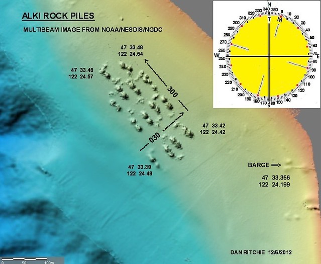
GPS coordinates for north end of reef for boat access:
47deg 33.439
122deg 24.440
Directions: Can launch at Don Armeni. Or drive to shore access site.
Here's a map with scooter heading for the shore access.
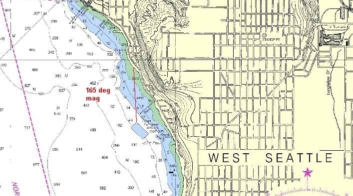
You scooter over a long shallow stretch ever so slightly getting deeper. Takes about 12 mins before you pass beyond the eelgrass zone (~25ft). Once you hit 40ft starting looking to your right and you'll see the northeasternmost rockpile.
For boat access go to the coordinates and then start using the depthsounder to find a rock pile to dive (generally to the south).
Free Parking: Yes at viewpoint, no at boat boat ramp.
Staging Area: good
Surface Swim: none
Nearby Facilities: porta-pottie across street from viewpoint. Also a toilet at the Don Armeni launch ramp.
Special Considerations: Not possible to do this dive as a shore dive. Its about 0.35 nautical miles (>2000ft) from the stairs to just the north end of the reef and occasional boat traffic. Fishing/boating activity is highest here during lingcod season (May-June). Should only be scootered/kayaked at high tide and on a calm day, the stairs for access are super slippery and algae covered. And there's no hand railing. At low tide you'll have to slog across some sand/gravel from the stairs to the water.
Maximum Depth: 70ft
Dive Site Description: About 10 piles of boulders and concrete rubble in two rows, one shallow, one deep row. Each pile is about 150-200ft long 60ft wide and 25ft tall. They were dumped here in the 1970s by WDFW. If on a scooter you can get out here, check out a bunch of the piles and return to shore on a 60 min battery no problem. If boat diving and swimming I tend to just find one pile, anchor nearby, and dive it slowly. Then if time permits use a spool or reel to find another pile nearby. The piles are between 50ft and 200ft apart depending on which rock pile you're at and which one you're heading to.
Lots of metridiums, copper rockfish, small lingcod, and perch at the rockpiles. Nudibranchs and seapens in the sand around them.
Skill Level: Intermediate from boat, Advanced via scooter (easy to get lost/seperated this way)
Current Sensitive: No, slight surface currents possible during exchanges fairly easy to swim against.
Location/Address: Emma Schmitz Viewpoint, 4503 Beach Dr. SW about 1.5 miles south of the lighthouse for shore/scooter/kayak access.
GPS coordinates for north end of reef for boat access:
47deg 33.439
122deg 24.440
Directions: Can launch at Don Armeni. Or drive to shore access site.
Here's a map with scooter heading for the shore access.
You scooter over a long shallow stretch ever so slightly getting deeper. Takes about 12 mins before you pass beyond the eelgrass zone (~25ft). Once you hit 40ft starting looking to your right and you'll see the northeasternmost rockpile.
For boat access go to the coordinates and then start using the depthsounder to find a rock pile to dive (generally to the south).
Free Parking: Yes at viewpoint, no at boat boat ramp.
Staging Area: good
Surface Swim: none
Nearby Facilities: porta-pottie across street from viewpoint. Also a toilet at the Don Armeni launch ramp.
Special Considerations: Not possible to do this dive as a shore dive. Its about 0.35 nautical miles (>2000ft) from the stairs to just the north end of the reef and occasional boat traffic. Fishing/boating activity is highest here during lingcod season (May-June). Should only be scootered/kayaked at high tide and on a calm day, the stairs for access are super slippery and algae covered. And there's no hand railing. At low tide you'll have to slog across some sand/gravel from the stairs to the water.
Maximum Depth: 70ft
Dive Site Description: About 10 piles of boulders and concrete rubble in two rows, one shallow, one deep row. Each pile is about 150-200ft long 60ft wide and 25ft tall. They were dumped here in the 1970s by WDFW. If on a scooter you can get out here, check out a bunch of the piles and return to shore on a 60 min battery no problem. If boat diving and swimming I tend to just find one pile, anchor nearby, and dive it slowly. Then if time permits use a spool or reel to find another pile nearby. The piles are between 50ft and 200ft apart depending on which rock pile you're at and which one you're heading to.
Lots of metridiums, copper rockfish, small lingcod, and perch at the rockpiles. Nudibranchs and seapens in the sand around them.